
view at the Nankoweap Granaries
When a trip that’s long been on your bucket list finally becomes reality, there’s a mix of excitement and, in this case, a bit of trepidation. That’s how I felt as I launched from Lee’s Ferry on a seven-day, 188-mile rafting journey through the Grand Canyon with Western River Expeditions. From roaring rapids and ancient ruins to new friendships and moonlit skies, this was a singular experience.
This trip was a 7-day trip booked through Western River Expeditions, a trusted outfitter known for its motorized “J-rig” raft trips. Unlike oar-powered trips, the J-rig covers more ground in less time—ideal for a weeklong adventure. Trips run from May through September and sell out quickly, often over a year in advance. The minimum age for the one-week trip is 12 years old, and a moderate level of fitness is beneficial, especially for the 7-day trip, which includes more hiking.
Table of contents: ()
What to Pack and What to Expect
Western provides waterproof dry bags, a sleeping kit (including a cot, sleeping bag, and sheet), and all meals. You’ll need to pack your own quick-dry clothing, river sandals, a hat with a chin strap, sunscreen, and personal hygiene items. Most people sleep under the stars, although tents are available. There is no phone service for a week, so bring one along only to take pictures and listen to podcasts.
Camp life is simple but comfortable. Mornings start with cowboy coffee and breakfast, followed by gear loading and river miles. Evenings bring hearty meals and casual conversation with a group of people who change from strangers to friends over the course of the adventure.
Packing for A Grand Canyon Rafting Trip

Riding the J-Rig and Meeting the Crew
The J-rig is a marvel of river engineering with five inflatable pontoons with multiple seating areas, including nine spots on the pontoons in the front, six seats on the coolers behind that that are a tad less wet, the drier “chicken coup” behind that where you face the canyon walls, and the “princess seat” which is the the driest seat just in front of the boat captain.
We had a group of 28 guests and 4 crew aboard two motorized J-rig rafts. Each raft carried its own gear, coolers, dry bags, water jugs, and water filters. Each raft had an experienced boat captain and a deckhand called a “swamper” (from back in the day, when bailing the boat was part of the job). The crew was filled with stories about the geology, the history, and the lore of the canyon.
A Day-by-Day Journey Downriver


Day 1: Las Vegas to Page, Arizona
Our first day of rafting started long before we hit the river. I met with part of our group at 4:45 am at the Las Vegas Marriott, where we had a sack breakfast at the hotel before boarding a bus to Boulder City. From there, we climbed into a small Grand Canyon Airlines plane and flew east to Page, Arizona. The flight flew over Hoover Dam and then across Nevada and Arizona, offering gorgeous views, though we didn’t quite catch a glimpse of the canyon itself.

Day 1: Lee’s Ferry to Ledges (Mile 18)
In Page, we met up with the rest of our rafting crew and made one last stop at a convenience store to grab any final snacks or drinks. Then it was off to Lees Ferry, the official launch point for all Grand Canyon rafting trips, where our river adventure really began.
At the put-in, we were handed our gear: a large dry bag with a tarp, sheet, sleeping bag, and water bottle, plus a smaller dry bag for things we’d want to access during the day, and a lifejacket. This wasn’t a roll-your-suitcase vacation—everything we brought had to be in a duffel bag. Although June is usually dry in the canyon, it had already started to drizzle as we packed up. I threw on my rain gear, which doubled as sun protection, and climbed aboard the raft.
Before 9 am, we were on the Colorado River. The canyon walls slowly closed in around us as we motored under the Navajo Bridges and into Marble Canyon, which John Wesley Powell (first to run the Colorado River) had optimistically named for its smooth rock formations (even though there’s no actual marble). That first day on the water was fairly mellow, perfect for easing into river life.

We hit our first few rapids—Six Mile Riffle, Badger Creek, and Soap Creek—and stopped to see the spot where F.M. Brown drowned in 1889 during an ill-fated attempt to survey the canyon for a railroad. It was a sobering reminder of how remote and wild this place still is, despite how easy our journey was in comparison.
We pulled off the river around 2:30 in the afternoon at a campsite called Ledges, just 18 miles downstream. Campsites aren’t reserved, so it’s first come, first served—and that means finishing early to secure a good spot. Ledges was narrow and a little cramped, with tents and cots arranged tightly on the sandy beach.
Once we formed a fire line to unload gear, we set up camp and got ready for dinner. That night’s meal—steak, grilled onions, and asparagus—was far better than you might expect in the middle of the wilderness.
Most of us chose to sleep under the stars instead of pitching tents, lulled into a false sense of security by the season. But sometime during the night, the rain returned, six different times, in fact, including a thunderstorm. We all ended up huddled under our tarps like green burritos, trying to keep dry. It was a memorable first night.
Day 2: To Dinosaur Camp (Mile 50)
On the second day of the rafting trip, we woke to a little more rain—this time, falling gently after breakfast as we packed up camp and loaded the gear back onto the rafts in reverse fire line.
The weather stayed cool and wet through the morning, and I was grateful for my rain gear, especially since we hit a string of rapids known collectively as the “20-mile rapids,” which fall between mile 20 and mile 30 from Lees Ferry. Running those rapids in the rain, while soaking wet and chilly, was a true Grand Canyon experience. Just as we emerged into a patch of sunshine and started to warm up, we pulled off for lunch—inside a cave.
That cave, known as Redwall Cavern, is massive. John Wesley Powell once estimated it could hold 50,000 people, which is certainly an exaggeration, but it’s easy to see how it left an impression. We shared the space with another rafting group that included disabled veterans, some in wheelchairs or with prosthetic limbs, and it was impressive to see them navigating such a rugged environment.

At the mouth of the cave, you could spot ancient marine fossils, trilobites and mudworms, from a time when this region was covered by a sea. You really get a sense of deep time in the Grand Canyon; we were well into the sedimentary layers by now, and the deeper we went, the older the rocks became.
The afternoon was more relaxed, with smaller rapids and a glimpse at what could have been a drastically different canyon. We passed the proposed site of a dam that was never built—thanks in part to a clever Sierra Club campaign that likened flooding Marble Canyon to flooding the Sistine Chapel. That bit of activism helped spark the modern environmental movement, and it’s now illegal to build dams in national parks.

That evening, we camped near mile 50 at Lower Dinosaur Camp. Ironically, everyone set up tents—unlike the previous night—but it didn’t rain again for the rest of the trip. Go figure.
Day 3: To Carbon (Mile 65)
On the third day of the trip, we woke up to a much drier and more pleasant morning. After breakfast and packing up camp, we set out on what would be one of the most memorable and physically demanding days of the trip.

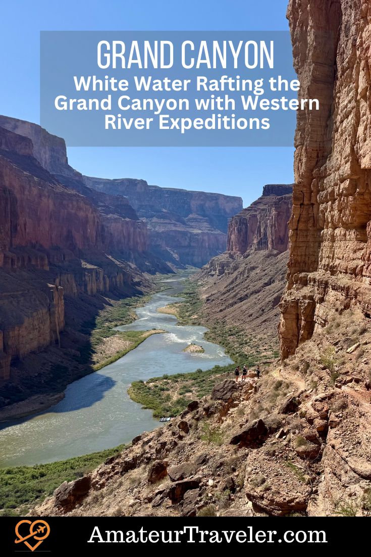
Early in the day, we stopped for a hike up to the Nankoweap Granaries, some of the best-preserved ancestral Puebloan structures in the Grand Canyon. The hike up was no joke—earning the nickname “the Stairmaster of Death”—as it climbed steeply up a 45-degree slope. I quickly realized I was both the oldest and probably the least fit person in the group, and I had to take my time getting to the top. But I made it, and it was worth every step.
From the granaries, we were treated to one of the most iconic views of the Colorado River—so stunning, in fact, that it was featured on the Grand Canyon National Park quarter (see the first photo in this article). Our guide, Jeff, shared a detailed explanation of the ancestral Puebloans, who lived in the region between roughly 500 and 1250 AD. He talked about their extensive trade networks, farming practices, and how they used granaries to store surplus food, even vacuum-sealing their grain using fire to remove oxygen. It was a fascinating window into a civilization that once thrived in these now-remote canyons.
Later that day, we hit a major milestone: the confluence with the Little Colorado River at mile 62. This also marked the official beginning of the Grand Canyon proper—up to this point, we had been traveling through Marble Canyon. Normally, the Little Colorado is known for its vivid turquoise blue water, but because of recent rains and flash floods, it was a swirling mess of muddy brown water. Our group still hiked up the Little Colorado for a bit, and some swam the muddy rapids, but most of us opted to sit that one out. A few were blowing mud out of their noses for days afterward.
We also passed a haunting bit of aviation history—a side hike from our lunch stop led to the crash site of a 1956 mid-air collision between a TWA and a United Airlines plane, a tragedy that helped spur the creation of the FAA.

For the rest of the trip, the river would run muddy. This makes a difference on the trip as the only water you can wash with is river water. Also, that smile you get when you go through the rapids gets a bit gritty. It should be noted that since you also have to take out everything you bring into the canyon, the instructions are to pee in the river so as not to fill the portable toilet with fluids and fill it up sooner.
A word should be said about toilets. Two will be set up in camp. One will be in a small tent, and one will be outside, further away from camp. When the tent flaps of the first are open, then it is your turn. For the outdoor one, you grab the Frisbee that is used to indicate that the toilet is in use. You will have a toilet seat, toilet paper, and a box upon which the toilet seat is mounted.
That evening, we camped at mile 65, at the mouth of Carbon Creek, within view of the Desert View Watchtower on the South Rim. It felt surreal to be drifting below a part of the canyon I’d seen from above before. The night was warm, the stars were bright, and I didn’t even bother pulling out my sleeping bag until a cool breeze rolled in around 2 a.m.
Day 4: To Hotauta (Mile 108)
The fourth day was both the most exciting and the most intimidating day of the trip—it was our big rapid day. We started at mile 65 and by the end of the day had traveled all the way to mile 108, covering 43 miles. That meant not only more river miles but also some of the biggest and most famous rapids in the canyon.
Geologically, this day was remarkable because we entered the Upper Granite Gorge, where the geology of the canyon changes dramatically. The rock here is the dark, ancient Vishnu schist, cut through with dramatic intrusions of red Zoroaster granite. These rocks are some of the oldest in North America, and the canyon narrows as the river cuts through this harder material. As a result, the rapids are steeper, rougher, and more exhilarating. This was the most visually stunning stretch of the trip—jagged black walls, roaring water, and a sense of being deep in the earth’s history.
The rapids came fast and hard. We hit Hans Rapid, Sockdolager, and eventually Hermit Rapid, which ended up being the highlight of the day for nearly everyone. Hermit didn’t have the highest technical rating, but it delivered wave after wave after wave—five in quick succession—that had everyone in the front of the raft ducking and screaming with joy (and maybe a little fear). That’s the rapid where Joanna, one of the guests, lost her grip on the rope mid-run, fell forward before the next wave stood her up, and she grabbed the rope again. It was the most dramatic moment of the trip and a story we kept retelling around camp.
Surprisingly, one of the two rapids we had feared most—Crystal Rapid, a Class 10—was comparatively smooth. Our boat captain, Ronnie, ran it perfectly, and it passed without the drama we had expected. That was a reminder that the 10-point rapid rating system in the Grand Canyon is based on technical difficulty for the guide, not on how wild the ride feels to the passengers.
Along the way, we passed Phantom Ranch and the Kaibab Suspension Bridge, familiar territory for hikers but a surreal checkpoint from the river. We also saw ongoing construction for water infrastructure improvements, including a pipeline replacement. It reminded us just how remote yet managed this place really is.

By the time we pulled into Hotauta Camp at mile 108, the temperature had climbed to 100°F. The black schist rock held the heat like a furnace. One of the best tricks I learned that night was to dunk the cotton sheet they gave us in the river and sleep under it wet—instant evaporative cooling. It made the sweltering evening much more bearable.
The fifth day of our Grand Canyon rafting trip was what I came to think of as waterfall day. After the nonstop rapids and intense heat of the day before, this was a more relaxed and refreshing stretch, still filled with adventure, but with moments to pause and soak in the canyon (literally and figuratively).
The day began with more rapids—one of which we ran backwards, unintentionally. We’d lost something off the boat, and by the time Ronnie had it back in hand, the raft was out of position for the next rapid, so we just went through it in reverse. It wasn’t graceful, but it worked.

Our first stop was Cheyava Falls near mile 108.5—a short hike led us to a small waterfall with a hollowed-out space behind it. We squeezed through a narrow, shadowy crack in the rock and emerged behind the cascade, water spilling over us in a chilly but welcome curtain. It wasn’t the biggest waterfall of the day, but it was the most surprising—one of those little Grand Canyon side treats you wouldn’t even know was there unless someone pointed it out.
Later, at mile 116.5, we reached Elves Chasm, a gorgeous, shaded grotto with another waterfall—this one larger and more dramatic. The water was still cold but refreshing. Soap is not allowed in side canyons, but it felt amazing to rinse off, especially for my hair, which hadn’t seen anything but muddy river water in days. It was one of the most photogenic spots on the whole trip, with mossy rocks and a natural plunge pool that made it hard to leave.
By this point, we’d exited the Upper Gorge, returned briefly to younger sedimentary rock, and then re-entered the Middle Granite Gorge around mile 127. That meant more black schist, more rapids, and even narrower canyon walls. The rapids here came quickly: Forester, Fossil, Specter, Bedrock, and Dubendorf—all solid class 5 to 8 rapids, with thrilling drops and fast-moving water.

Our final stop of the day was Stone Creek, another waterfall, and this one stole the show. The volume of water crashing down the cliff created its own wind system; as we approached the falls, the gusts pushed us back. Some of us stayed at the waterfall, just soaking it in, while others hiked up a steep ledge to a narrow slot canyon feeding the waterfall. That section wasn’t for everyone—exposed edges and a serious drop-off made it a no-go for those with a fear of heights (like me), but everyone, hikers and swimmers alike, came back with huge grins.
We camped that night at mile 137, at a site nicknamed Football. It had a small cave at one end, and some of us slept under the overhang, sharing the space with a few bats who flitted out at dusk.
Day 6: To Lower 185 (Mile 185)
Day six was our final full day on the river, and it stood out for three big reasons: volcanoes, waterfalls, and Lava Falls—the most infamous rapid in the Grand Canyon.

Geologically, the landscape was changing again. We were now in the section where ancient lava flows had once poured over the canyon walls, forming basalt dams that temporarily blocked the Colorado River. These were relatively recent events in Grand Canyon time—just a couple of million years ago—and the remnants are everywhere in this stretch. Massive, black, hexagonal basalt columns twisted and stacked like a collapsed cathedral, a stark contrast to the canyon’s sedimentary layers. It felt like we were rafting through a different world.
But before we got to the day’s headline rapid, we had a different highlight: a side hike into Havasu Canyon. It was an early start, with a quick continental breakfast so we could beat other groups to the canyon, and we beached at a tricky landing known as “the Garage,” right in the middle of a small set of rapids. Tying up there was a balancing act—swampers leapt off to secure the lines while we kept our life jackets on in case of a misstep.
Once ashore, we hiked along rocky ledges above the stream until the canyon opened up into a series of turquoise-blue pools and travertine terraces—or at least, they should have been turquoise. Earlier flash floods had turned the normally crystalline water cloudy, but it was still stunning. Some of us sat in the pools and soaked. Others jumped off rocks or hiked deeper into the canyon. I just sat in the cool water for over an hour, enjoying a rare chance to relax completely. Even with the flash-flood sediment, it was still warmer than the Colorado and felt like luxury.
Later that afternoon, we continued downstream toward Lava Falls, the rapid everyone had been thinking about all week. Just before the run, we passed Vulcan’s Anvil, a volcanic plug standing like a warning sentinel in the middle of the river. It was our cue to tighten helmets and grab the ropes. Lava Falls is rated a 10 on the Grand Canyon’s unique scale—a true beast. But, to our surprise, it turned out to be a good, clean run. Ronnie handled it like a pro. While it was thrilling, Hermit Rapid earlier in the trip was still more intense and memorable for most of us.

We camped that night at Lower 185 Mile Camp, just three miles upstream from where we’d be helicoptered out the next morning. The last night had a celebratory feel.
We had trout for dinner—not river-caught, but carefully packed and preserved for six days. It was toga night. Using the cotton sheets we’d been sleeping under, we fashioned makeshift togas and shared laughs, stories, and highlights from the trip. We also had Bananas Foster with ice cream, which is a surprise this far into the canyon.
It was a beautiful final night, and even though the end was in sight, none of us really wanted it to be over… although the thought of a hot shower sounded pretty good.
Day 7: Takeout at Whitmore Wash (Mile 188)
The seventh and final day of our Grand Canyon rafting trip was a mix of logistics and reluctant goodbyes. We were only three miles from our take-out point at mile 188, where a helicopter would carry us out of the canyon. It wasn’t quite a helipad—just a flat stretch of canyon floor where helicopters land—but it felt surreal all the same.
We started early and transferred everything from our dry bags into travel bags and lined up to be weighed for the helicopter flight. The process was quick and well-orchestrated. I ended up flying out with an earlier group to balance the load, which meant I got a bonus moment: the peace and quiet of Bar 10 Ranch, freshly showered, before the rest of the group arrived.
Bar 10 Ranch is perched on a plateau above the canyon, still remote with no cell service or Wi-Fi, but a return to running water, flush toilets, and even a shower. After six days on the river, those small comforts felt like luxury. I shaved, cleaned up, and relaxed on the shaded porch, watching other guests slowly trickle in by helicopter six at a time. We shared one last lunch together—cold sandwiches and snacks—before our final flight out.

From the ranch, we boarded small planes once again with Grand Canyon Airlines. Some flew to Page, others like me, back to Boulder City. A final bus dropped me at McCarran Airport in Las Vegas while the rest of the group returned to the hotel where the adventure had begun.
Tips for Future Rafters
- Don’t overpack; less is more.
- Ladies, bring a sarong—it’s the Swiss Army knife of river gear.
- Be ready to sleep under the stars.
- Trust the guides—they know the canyon like family.
Final Thoughts
Rafting the Grand Canyon isn’t just a vacation—it’s a pilgrimage. Whether it’s the roar of Hermit Rapid or the quiet glow of dawn on a canyon wall, the river has a way of staying with you long after the trip ends. I don’t know if I have been on any other trip where there is a new picture-worthy vista around every corner for 188 miles and 7 days. If you ever get the chance, say yes and hold on tight.
Listen to more of my adventure at Rafting the Grand Canyon with Western River Expeditions – Amateur Traveler Episode 950.
My trip on Western Rivers Expeditions was sponsored (paid for) by the company. All the opinions expressed are my own.
amateurtraveler.com (Article Sourced Website)
#White #Water #Rafting #Grand #Canyon #Western #River #Expeditions #Amateur #Traveler