In the 19th century, Alfred Russel Wallace (famous for coming up with his own theory of evolution by natural selection, independent of Charles Darwin) was wandering through the Malay Archipelago with a butterfly net and a notebook, documenting what would become one of biology’s most surreal puzzles.
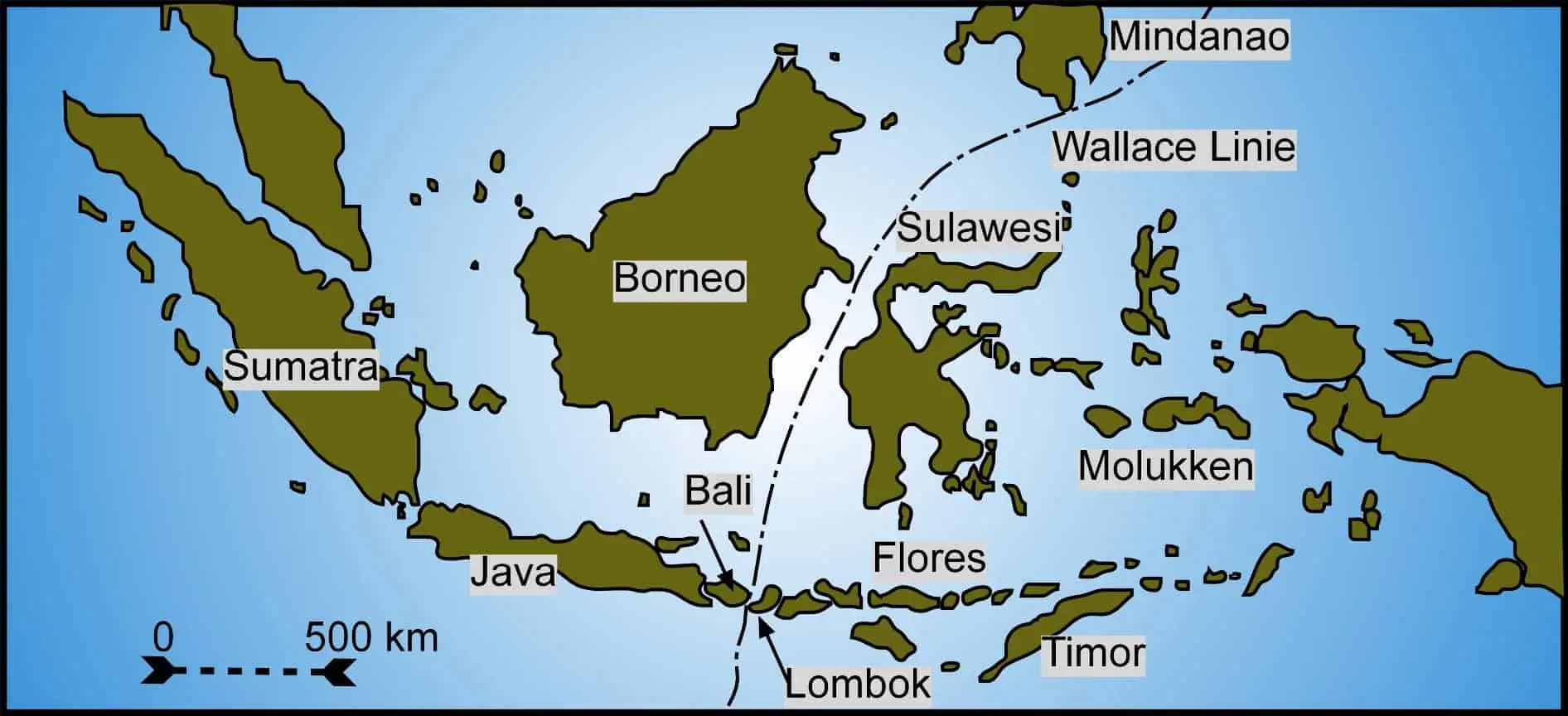
On the island of Bali, he saw familiar animals common in Asia: monkeys, wild boars, and woodpeckers. But when he hopped across a mere 20-mile stretch of water to the island of Lombok, the ecosystem shifted entirely. Suddenly, he was in a world of honeyeaters, cockatoos, and tree-climbing marsupials.
It was as if a giant, invisible scythe had sliced through the ocean, decreeing that the lineages of two continents should never mix. For 160 years, we called this the Wallace Line, a biogeographical “No Trespassing” sign that remained one of science’s greatest cold cases.
Scientists now think they’ve finally solved the puzzle of the mysterious Wallace Line, explaining the uneven distribution of animal species on either side of this boundary. Using a massive computer model, biologists from the Australian National University and ETH Zurich found the Wallace Line was drawn as a result of high-speed continental collision and a subsequent bout of global climate whiplash about 35 million years ago.
The Wallace Line
Alfred Russel Wallace, a self-taught naturalist of humble origins, arrived in the Malay Archipelago in 1854 with the intent of solving the problem of the origin of species. Over the course of eight years, Wallace traveled more than 14,000 miles and amassed a staggering collection of 125,660 specimens, including thousands of insects, birds, and mammals new to Western science. His method was grueling; he spent hours daily on his knees in wet sand and rotting leaves, enduring malaria and dysentery to document the staggering diversity of the tropics.
Wallace’s epiphany occurred in 1856 when he crossed the Lombok Strait. Expecting a gradual transition of species as he moved from Bali to Lombok, he was instead confronted by a radical change in the biological landscape. The birds that were common on Bali—barbets, fruit thrushes, and woodpeckers—simply vanished, replaced by Australian forms like the mound-building megapodes and the noisy cockatoos. This observation led him to propose a faunal boundary that tracked through the Makassar Strait and between Mindanao and the Moluccas, effectively splitting the archipelago into an Indo-Malayan region and an Austro-Malayan region.
His work was supported by a network of local assistants, most notably a Malay youth named Ali, whose skills in collecting and skinning specimens were essential to the naturalist’s success. Ali was responsible for gathering and cataloguing countless specimens that allowed Wallace to construct a theory of biogeography. This discipline, of which Wallace is considered the father, posited that the distribution of life is not random but is fundamentally linked to the geological history of the land.
| Taxon Group | West of the Line (Bali, Borneo, Java) | East of the Line (Lombok, Sulawesi, New Guinea) |
| Mammals | Monkeys, tigers, rhinos, squirrels, civets | Marsupials (cuscus), monotremes, tree kangaroos |
| Birds | Woodpeckers, barbets, trogons, pheasants | Cockatoos, honeyeaters, lories, megapodes |
| Insects | High diversity of Carabidae and Asian longhorns | Distinct Australian-derived beetle and butterfly clades |
| Freshwater Fish | Cyprinids, catfishes (Sundaic origin) | Very few; primarily those capable of saltwater tolerance |
| Amphibians | Oriental frogs (Megaphrys, Microhyla) | Limited representation; some Australian frog lineages |
The Wallace Line delineates two distinct zones of animal and plant life. But the curious thing about this line is that it exists despite the geographical proximity of the islands. One might expect a gradual transition of species between areas so close, but that’s not the case here.
It’s as if someone drew a line and said, ‘On this side, you get Asia. On the other, you get Australia.’ Only it wasn’t some divine being that drew the line, but rather natural forces.
But what exactly happened?
To understand why the Wallace Line exists, one must look back tens of millions of years into deep time, to a period when the map of the Earth was being radically reorganized by plate tectonics. Approximately 50 million years ago, Australia began its long northward journey after breaking away from Antarctica. For eons, Australia had been an isolated island continent, its flora and fauna evolving in a cooler, increasingly drier climate as it drifted away from the southern pole.
As Australia drifted north, it eventually collided with the southeastern edge of the Eurasian plate. This tectonic process eventually birthed the volcanic islands of the Indonesian archipelago. This geologically complex archipelago acted as a series of stepping stones, potentially allowing species to hop from one landmass to another. However, the deep ocean trenches and the persistent marine barriers of the Wallacea region—the transition zone between the Sunda and Sahul shelves—remained a formidable obstacle for most terrestrial vertebrates.
The convergence of the Australian and Eurasian plates also triggered profound changes in the global climate system. The opening of the Drake Passage and the Tasmanian Gateway allowed for the eventual development of the Antarctic Circumpolar Current (ACC). While the exact timing of the ACC’s onset remains controversial, with some models suggesting it began near the Eocene-Oligocene boundary approximately 34 million years ago and others pointing to a later development in the Miocene around 14 million years ago, its effect was undeniable: it thermally isolated Antarctica, leading to the formation of massive ice sheets and a global cooling trend.
Stepping stones across Indonesia
By the Early Oligocene, the climate had cooled significantly, and many warm-adapted lineages were forced toward the equator or faced extinction. For the species of the Indo-Australian Archipelago, this meant that the environment they inhabited was in a constant state of flux, driven by the dual forces of drifting continents and a cooling planet.
While the role of plate tectonics in creating the Wallace Line was well-established by the late twentieth century, a central mystery persisted: the asymmetry of the faunal exchange. Biologists observed that species exchange rates across the line were at least twice as high from west to east—from Asia to Australia—than in the opposite direction. Asian lineages, such as shrews and rodents, had successfully colonized the Australian shelf, whereas Australian marsupials had largely failed to establish a foothold in Southeast Asia.
This imbalance is explained by a 2023 study by biologists at the Australian National University (ANU) and ETH Zurich in Switzerland, who ran a computer model that predicts how this ancient tectonic event affected the range and diversification of species. This model revealed that the changing climate affected species differently on both sides of the Wallace Line.
Utilizing a sophisticated mechanistic model called Gen3SIS, which stands for General Engine for Eco-Evolutionary Simulations, the researchers analyzed the diversification and movement of more than 20,000 vertebrate species—including mammals, birds, reptiles, and amphibians—across 227 families. By combining paleoenvironmental reconstructions of temperature and precipitation with plate tectonic movements over the last 30 million years, the study sought to determine which biological traits enabled successful colonization.
The findings pointed to precipitation tolerance as the decisive factor. The model showed that Asian lineages had evolved in humid, tropical climates. So these species were pre-adapted to the warm, wet conditions they encountered as they moved eastward toward New Guinea and the Australian shelf. In contrast, many Australian lineages had evolved in increasingly dry, arid conditions as Australia separated from Antarctica and drifted into lower latitudes. When these species attempted to move west, they were stymied by the humid tropical forests of Wallacea, which acted as an environmental filter.
“If you travel to Borneo, you won’t see any marsupial mammals, but if you go to the neighboring island of Sulawesi, you will. Australia, on the other hand, lacks mammals typical of Asia, such as bears, tigers or rhinos,” said lead researcher Dr. Alex Skeels from ANU.
Although the global cooling caused by the merger of Australia and Asia unleashed a mass extinction event, the climate on the newly formed Indonesian islands was relatively welcoming for life: it was warm, wet, and tropical, much like today.
“So Asian fauna were already well-adapted and comfortable with these conditions, so that helped them settle in Australia,” Skeels said.
“This was not the case for the Australian species. They had evolved in a cooler and increasingly drier climate over time and were therefore less successful in gaining a foothold on the tropical islands compared to the creatures migrating from Asia.”

The researchers hope that their computer model can help forecast how modern-day climate change will impact living species. By understanding how species adapted to historical climate changes, scientists can better predict which species may be more adept at adapting to new environments in the future.
The Wallace Line serves as a demonstration of how geographical and geological factors can influence biodiversity. But it is not the only example. Closer to the Wallace Line, you’ll find two other lines named after the scientists who discovered them: Weber’s Line and Lydekker’s Line.

Weber’s line runs east of the Wallace Line and shows a gradual transition from Asian to Australian species. Further east is Lydekker’s Line, which borders the edge of the Australian continent. Beyond this point, the species are predominantly Asian.
The Aïr and Ténéré Line is another fascinating biogeographical boundary. It runs through the Sahara Desert in Niger, separating the Western Saharan flora from the Eastern Saharan flora. Despite the harsh conditions, the regions on either side of this line boast different plant species adapted to their specific environments.
As the planet warms at an unprecedented rate, understanding these boundaries has never been more urgent. Although their boundaries may be invisible, their impact is very much real.
The findings appeared in the journal Science.
www.zmescience.com (Article Sourced Website)
#Wallace #Line #Forms #Invisible #Barrier #Tigers #Koalas #Meeting #Finally #Happened